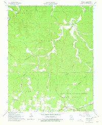
1964 Map of Bartlett
USGS Topo · Published 1979About this map
The St Louis San Francisco Railroad corridor anchors the southern edge of this landscape, passing through the small settlement of Bartlett and past a local Drive-in Theater. This mid-century survey reveals a rural Missouri Ozarks terrain defined by deep hollows and timberland, much of which is protected within the Mark Twain National Forest. Water sources are vital to the local geography, from the winding Jacks Fork in the northwest to the isolated Buckhart Spring. Further north, the community of Delaware sits near the Rader Cem, illustrating the dispersed nature of settlement in Shannon County. The map provides a clear record of family-named landmarks and topographic features like Jam Up Hollow and Pin Oak Hollow, while the Magger of Bethlehem Ch stands as a focal point for the local congregation south of the tracks.
Find a feature on this map
33 named features on this map. Tap any name to fly to it.
Don’t see what you’re looking for? This feature index may not catch every label — zoom into the map to look around manually.
Map Details
Editions of this 1964 Bartlett Map
3 editions found
Other maps of this area

1915 · Eminence
USGS Topo · 1:62,500

1917 · Eminence
USGS Topo · 1:62,500

1931 · Bandyville
USGS Topo · 1:48,000

1944 · Birch Tree
USGS Topo · 1:62,500

1945 · Montier
USGS Topo · 1:62,500

1946 · Summersville
USGS Topo · 1:62,500

1948 · Montier
USGS Topo · 1:62,500

1948 · Birch Tree
USGS Topo · 1:62,500

1948 · Summersville
USGS Topo · 1:62,500

1949 · Rolla
USGS Topo · 1:250,000