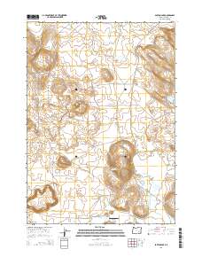
2014 Map of Barton Lake
USGS Topo · Published 2014About this map
Diamond Craters dominates the southwestern corner of this landscape, marking a volcanic terrain within the high desert of Harney County. The area’s water management history is evident through a network of irrigation and storage features, including the Highline Ditch and Feed Canal which redirect flow toward Dry Lake Reservoir. This reservoir, along with the nearby Dry Lake Waterhole, suggests a landscape engineered for ranching and livestock in an otherwise arid environment. Evidence of local aviation and transport infrastructure appears through the Barton Lake Ranch Airport and the descriptively named Lava Bed Rd, which cuts across the central and northern plains. Smaller water bodies like White Lake and the drainage of Riddle Cr further define the hydrological character of the region during this 2014 survey by the U.S. Geological Survey.
Find a feature on this map
13 named features on this map. Tap any name to fly to it.
Don’t see what you’re looking for? This feature index may not catch every label — zoom into the map to look around manually.
Map Details
Editions of this 2014 Barton Lake Map
This is the sole edition of this map. No revisions or reprints were ever made.
Other maps of this area

1955 · Burns
USGS Topo · 1:250,000

1958 · Burns
USGS Topo · 1:250,000

1959 · Burns
USGS Topo · 1:250,000

1959 · Lawen
USGS Topo · 1:62,500

1960 · Crane
USGS Topo · 1:62,500

1967 · Happy Valley
USGS Topo · 1:24,000

1967 · Jackass Butte NE
USGS Topo · 1:24,000

1967 · Barton Lake
USGS Topo · 1:24,000
1967 · Diamond Swamp
USGS Topo · 1:24,000

1967 · Diamond
USGS Topo · 1:24,000