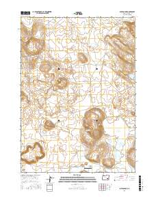
2017 Map of Barton Lake
USGS Topo · Published 2017About this map
Diamond Craters dominates the southwestern corner of this landscape in Harney County, illustrating the volcanic history of the high desert. This 2017 survey shows a region where water management is critical to ranching and local aviation, centered on the Barton Lake Ranch Airport. The hydrography reveals an intricate system of natural and man-made water features, including Barton Lake, the Dry Lake Reservoir, and the Dry Lake Waterhole. Movement through this arid terrain is facilitated by Diamond Loop Rd and Diamond Craters Rd, which connect the isolated water sources and ranching infrastructure. Engineering efforts to move water across the basins are evident in the Feed Canal and Highline Ditch, which work alongside natural drainage like Riddle Cr.
Find a feature on this map
15 named features on this map. Tap any name to fly to it.
Don’t see what you’re looking for? This feature index may not catch every label — zoom into the map to look around manually.
Map Details
Editions of this 2017 Barton Lake Map
This is the sole edition of this map. No revisions or reprints were ever made.
Other maps of this area

1955 · Burns
USGS Topo · 1:250,000

1958 · Burns
USGS Topo · 1:250,000

1959 · Burns
USGS Topo · 1:250,000

1959 · Lawen
USGS Topo · 1:62,500

1960 · Crane
USGS Topo · 1:62,500

1967 · Happy Valley
USGS Topo · 1:24,000

1967 · Jackass Butte NE
USGS Topo · 1:24,000

1967 · Barton Lake
USGS Topo · 1:24,000
1967 · Diamond Swamp
USGS Topo · 1:24,000

1967 · Diamond
USGS Topo · 1:24,000