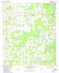
1982 Map of Bascom
USGS Topo · Published 1982About this map
The Chattahoochee River defines the eastern edge of this agricultural landscape in the early 1980s, serving as the border between Florida and Georgia. Near the Herman E Talmadge Bridge, the riverbank features river-oriented infrastructure like the Boat Neals Landing Ramp and a nearby Campground. The interior of the sheet is marked by a network of rural roads connecting small settlements like Bascom and Hornsville, punctuated by numerous country churches such as Hickory Grove Ch and Mt Olive Ch.
Find a feature on this map
34 named features on this map. Tap any name to fly to it.
Don’t see what you’re looking for? This feature index may not catch every label — zoom into the map to look around manually.
Map Details
Editions of this 1982 Bascom Map
This is the sole edition of this map. No revisions or reprints were ever made.
Other maps of this area

1952 · Dellwood
USGS Topo · 1:24,000

1952 · Malone
USGS Topo · 1:24,000

1952 · Bascom
USGS Topo · 1:24,000

1952 · Marianna
USGS Topo · 1:24,000

1953 · Dothan
USGS Topo · 1:250,000

1954 · Dothan
USGS Topo · 1:250,000

1954 · Steam Mill
USGS Topo · 1:24,000

1954 · Tallahassee
USGS Topo · 1:250,000

1955 · Dothan
USGS Topo · 1:250,000

1955 · Fairchild
USGS Topo · 1:24,000