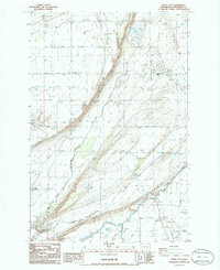
1986 Map of Basin City
USGS Topo · Published 1986About this map
Basin City serves as the focal point of this mid-1980s agricultural and irrigation landscape in Franklin County. The map illustrates a highly engineered environment where water management is central to the local economy, featuring a complex network of an Aqueduct, a Siphon, and a Weir to direct flow across the terrain. Large-scale farming infrastructure is evident through the numerous Storage Bins and a prominent Grain Elevator situated near the Ringold Substation. Significant earthworks, including a Levee, Split Levee, and multiple Spoil Banks, reflect the intensive modification of the land. Social and utility hubs are also visible, ranging from the central Rodeo Grounds and Trailer Park to the industrial operations at the Gravel Pit. The presence of a Pumping Station and expansive Potholes further defines the unique hydrogeology and resource management of the region during this era.
Find a feature on this map
21 named features on this map. Tap any name to fly to it.
Don’t see what you’re looking for? This feature index may not catch every label — zoom into the map to look around manually.
Map Details
Editions of this 1986 Basin City Map
This is the sole edition of this map. No revisions or reprints were ever made.
Other maps of this area

1917 · Pasco
USGS Topo · 1:125,000

1924 · Hanford
USGS Topo · 1:62,500

1925 · Scooteney Lake
USGS Topo · 1:62,500

1951 · Scooteney Lake
USGS Topo · 1:62,500

1951 · Richland
USGS Topo · 1:62,500

1951 · Hanford
USGS Topo · 1:62,500

1953 · Walla Walla
USGS Topo · 1:250,000

1958 · Walla Walla
USGS Topo · 1:250,000

1965 · Mesa
USGS Topo · 1:62,500

1965 · Eltopia
USGS Topo · 1:62,500