
1965 Map of Eltopia
USGS Topo · Published 1966About this map
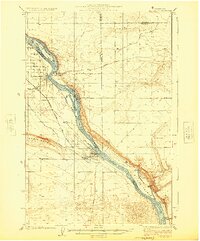
Esquatzel Coulee and its associated irrigation network define this mid-1960s landscape, illustrating the massive scale of the Columbia Basin Project. The map reveals a complex system of water management including the Potholes Canal, Esquatzel Diversion Channel, and numerous siphons and pumping plants like the Ringold Pumping Plant. These structures turned the arid landscape near Jackass Mtn into productive agricultural land, visible in the geometric grid of roads like Eltopia West Road and Taylor Flats Rd.
Find a feature on this map
68 named features on this map. Tap any name to fly to it.
Don’t see what you’re looking for? This feature index may not catch every label — zoom into the map to look around manually.
Map Details
Editions of this 1965 Eltopia Map
This is the sole edition of this map. No revisions or reprints were ever made.
Other maps of this area

1915 · Wallulah
USGS Topo · 1:96,000

1916 · Connell
USGS Topo · 1:125,000

1917 · Pasco
USGS Topo · 1:125,000

1918 · Connell
USGS Topo · 1:125,000

1918 · Wallula
USGS Topo · 1:125,000
1924 · Hanford
USGS Topo · 1:62,500

1925 · Scooteney Lake
USGS Topo · 1:62,500

1951 · Scooteney Lake
USGS Topo · 1:62,500

1951 · Richland
USGS Topo · 1:62,500

1951 · Hanford
USGS Topo · 1:62,500