
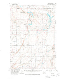
1965 Map of Mesa
USGS Topo · Published 1966About this map
Paradise Flats and the surrounding desert landscape of Franklin County were undergoing a massive hydrological transformation during the mid-1960s. The intricate network of irrigation infrastructure, including the Potholes Canal and the Eltopia Branch Canal, reflects the expansion of the Columbia Basin Project, turning arid rangeland into productive agriculture. The settlement of Basin City appears as a planned center for this growing farming community, while the Northern Pacific Railroad continues to follow the natural path of the Esquatzel Coulee through Mesa. On the higher ground, the Othello Air Force Sta stands as a Cold War landmark overlooking the developing valley. This map captures the region when large-scale water management was redefining the landscape, punctuated by local landmarks like the Bailie Memorial Boys Ranch and numerous water bodies such as Scooteney Reservoir and Eagle Lake.
Find a feature on this map
59 named features on this map. Tap any name to fly to it.
Don’t see what you’re looking for? This feature index may not catch every label — zoom into the map to look around manually.
Map Details
Editions of this 1965 Mesa Map
2 editions found
Other maps of this area

1915 · Wallulah
USGS Topo · 1:96,000

1916 · Connell
USGS Topo · 1:125,000

1917 · Pasco
USGS Topo · 1:125,000

1918 · Connell
USGS Topo · 1:125,000

1918 · Wallula
USGS Topo · 1:125,000

1923 · Corfu
USGS Topo · 1:62,500

1924 · Othello
USGS Topo · 1:62,500

1924 · Hanford
USGS Topo · 1:62,500

1925 · Scooteney Lake
USGS Topo · 1:62,500

1951 · Scooteney Lake
USGS Topo · 1:62,500