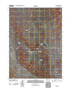
2011 Map of Basque
USGS Topo · Published 2011About this map
The settlement of Basque stands along the primary transit corridor in this high desert region of Malheur County, where ranching infrastructure defines the landscape. Water management is central to life here, as evidenced by a network of catchments including Bad News Reservoir, Big Bend Reservoir, and Black Sage Reservoir. These features, along with Little Flat Reservoir and Bellmare Reservoir, illustrate the critical importance of water storage for livestock in an arid environment.
Find a feature on this map
10 named features on this map. Tap any name to fly to it.
Don’t see what you’re looking for? This feature index may not catch every label — zoom into the map to look around manually.
Map Details
Editions of this 2011 Basque Map
This is the sole edition of this map. No revisions or reprints were ever made.
Other maps of this area

1955 · Jordan Valley
USGS Topo · 1:250,000

1957 · Jordan Valley
USGS Topo · 1:250,000

1958 · Jordan Valley
USGS Topo · 1:250,000

1979 · Bowden Ranch
USGS Topo · 1:24,000

1979 · Flat Top Mtn SE
USGS Topo · 1:24,000

1980 · Rome State Airport
USGS Topo · 1:24,000

1982 · Battle Mtn
USGS Topo · 1:24,000
1982 · Basque
USGS Topo · 1:24,000
1982 · Battle Creek Ranch
USGS Topo · 1:24,000
1982 · Three Man Butte Well
USGS Topo · 1:24,000