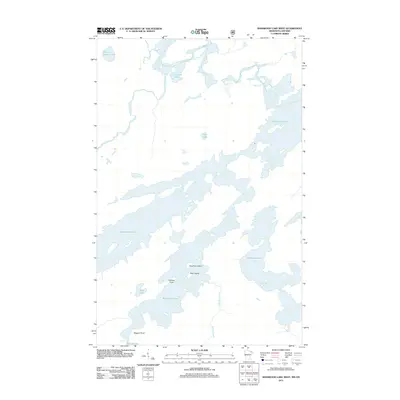
2011 Map of Basswood Lake West
USGS Topo · Published 2011About this map
Basswood Lake dominates this northern wilderness landscape along the international border, where the complex waterways of the Rainy River District meet the Minnesota boundary. The map illustrates a primitive aqueous network defined by significant drops in elevation, marked by Lower Basswood Falls, Wheelbarrow Falls, and Pipestone Falls. These landmarks underscore the historical portage routes utilized by travelers and indigenous people navigating the interconnected chain of lakes. To the west, the Horse River flows through a series of narrow channels connecting Section Sixteen Lake and Crooked Lake, while southern points like Wegens Point and Caribou Point provide navigational reference for the open waters of the basin. The presence of New York Island and Gary Island within the central lake system highlights the fragmented, glaciated terrain that has long dictated the movement of explorers and canoeists through this protected backcountry corridor.
Find a feature on this map
17 named features on this map. Tap any name to fly to it.
Don’t see what you’re looking for? This feature index may not catch every label — zoom into the map to look around manually.
Map Details
Editions of this 2011 Basswood Lake West Map
This is the sole edition of this map. No revisions or reprints were ever made.
Other maps of this area

1933 · Ely
USGS Topo · 1:62,500

1939 · Ely
USGS Topo · 1:62,500

1954 · Two Harbors
USGS Topo · 1:250,000

1957 · Two Harbors
USGS Topo · 1:250,000

1957 · Gabbro Lake
USGS Topo · 1:62,500

1957 · Basswood Lake
USGS Topo · 1:62,500

1957 · Quetico
USGS Topo · 1:250,000

1958 · Two Harbors
USGS Topo · 1:250,000

1963 · Fourtown Lake
USGS Topo · 1:24,000
1963 · Friday Bay
USGS Topo · 1:24,000