
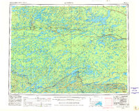
1957 Map of Quetico
USGS Topo · Published 1967About this map
Quetico Provincial Park and the Superior National Forest dominate this borderland landscape, illustrating the interconnected lake systems of the Ontario-Minnesota boundary. The map highlights a rugged transition between the wild Hunter Island interior and the industrial rail corridors to the north. Atikokan serves as a primary hub, situated near the iron-rich basin of Steep Rock Lake. Transport infrastructure is clearly defined, with the Canadian National Railways threading through small settlements like Sapawe, Kawene, and Kashabowie, while the Canadian Pacific Railway serves the northeastern corner through Savanne. Large water bodies including Lac des Mille Lacs, Saganaga Lake, and Basswood Lake reflect the complex geography that shaped early exploration and the modern conservation areas of the mid-20th century.
Find a feature on this map
39 named features on this map. Tap any name to fly to it.
Don’t see what you’re looking for? This feature index may not catch every label — zoom into the map to look around manually.
Map Details
Editions of this 1957 Quetico Map
2 editions found
Other maps of this area

1919 · Brule Lake
USGS Topo · 1:62,500

1933 · Ely
USGS Topo · 1:62,500

1939 · Ely
USGS Topo · 1:62,500

1954 · Two Harbors
USGS Topo · 1:250,000

1954 · Hibbing
USGS Topo · 1:250,000

1954 · International Falls
USGS Topo · 1:250,000

1956 · Crab Lake
USGS Topo · 1:24,000

1957 · Two Harbors
USGS Topo · 1:250,000

1957 · Hibbing
USGS Topo · 1:250,000

1957 · International Falls
USGS Topo · 1:250,000