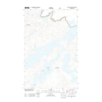
2013 Map of Basswood Lake West
USGS Topo · Published 2013About this map
The Superior National Forest dominates this borderland landscape, where the international boundary between Minnesota and Canada weaves through a complex network of glacial lakes and portages. This 2013 survey documents the intricate shoreline of Basswood Lake, a central feature of the Boundary Waters region, including its many indentations like Jackfish Bay, Pipestone Bay, and Hoist Bay. The movement of water through this wilderness is traced from Newton Lake up through Pipestone Falls, eventually reaching the massive expanse of the main lake. The map also captures the Horse River as it snakes toward the northwestern corner, connecting with Crooked Lake and the dramatic drop of Lower Basswood Falls. For those studying the history of northern travel and trade, the map illustrates the precise geography of named landmarks like Lewis Narrows, New York Island, and Caribou Point.
Find a feature on this map
24 named features on this map. Tap any name to fly to it.
Don’t see what you’re looking for? This feature index may not catch every label — zoom into the map to look around manually.
Map Details
Editions of this 2013 Basswood Lake West Map
This is the sole edition of this map. No revisions or reprints were ever made.
Other maps of this area

1933 · Ely
USGS Topo · 1:62,500

1939 · Ely
USGS Topo · 1:62,500

1954 · Two Harbors
USGS Topo · 1:250,000

1957 · Two Harbors
USGS Topo · 1:250,000

1957 · Gabbro Lake
USGS Topo · 1:62,500

1957 · Basswood Lake
USGS Topo · 1:62,500

1957 · Quetico
USGS Topo · 1:250,000

1958 · Two Harbors
USGS Topo · 1:250,000

1963 · Fourtown Lake
USGS Topo · 1:24,000
1963 · Friday Bay
USGS Topo · 1:24,000