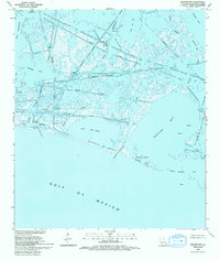
1993 Map of Bastian Bay
USGS Topo · Published 1995About this map
Industrial extraction and tidal hydrology define this coastal landscape in Plaquemines Parish, where the West Bastian Bay Oil and Gas Field sits amidst a complex network of marshes and open water. The map documents a territory heavily modified by human engineering, featuring numerous Pipelines and Canals that cut through the natural flow of Bastian Bayou and Huertes Bayou. Along the coastline, Bastian Island and Shell Island serve as fragile barriers between the interior bays and the open Gulf of Mexico. Scattered infrastructure including a Pumping Station, several Platforms, and various Drill Holes indicate the intensive resource recovery operations active during this era. The waterway system is intricate, with Grand Bayou Pass and Chaland Pass providing critical connections between the marshy interior and the sea.
Find a feature on this map
34 named features on this map. Tap any name to fly to it.
Don’t see what you’re looking for? This feature index may not catch every label — zoom into the map to look around manually.
Map Details
Editions of this 1993 Bastian Bay Map
This is the sole edition of this map. No revisions or reprints were ever made.
Other maps of this area

1892 · Quarantine
USGS Topo · 1:62,500

1893 · Fort Livingston
USGS Topo · 1:62,500

1935 · Port Sulphur
USGS Topo · 1:31,680

1935 · Bastian Bay
USGS Topo · 1:31,680

1935 · Bay Ronquille
USGS Topo · 1:31,680

1935 · Tropical Bend
USGS Topo · 1:31,680

1941 · Empire
USGS Topo · 1:62,500

1944 · Empire
USGS Topo · 1:62,500

1947 · Buras
USGS Topo · 1:31,680

1947 · Bay Ronquille
USGS Topo · 1:31,680