
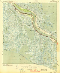
1944 Map of Empire
USGS Topo · Published 1944About this map
Port Sulphur and the Mississippi River dominate this deltaic landscape of Plaquemines Parish as it appeared in the late 1930s. The region is defined by a thin ribbon of habitable land protected by levees, where settlements like Empire, Buras, and Nairn cling to the river's edge. Beyond the immediate riverbanks, the terrain dissolves into an intricate network of marshes, canals, and bays, including California Bay and Quarantine Bay.
Find a feature on this map
100 named features on this map. Tap any name to fly to it.
Don’t see what you’re looking for? This feature index may not catch every label — zoom into the map to look around manually.
Map Details
Editions of this 1944 Empire Map
2 editions found
Other maps of this area

1891 · Pointe a La Hache
USGS Topo · 1:62,500

1892 · Quarantine
USGS Topo · 1:62,500

1892 · Pointe a La Hache
USGS Topo · 1:62,500

1893 · La Fortuna
USGS Topo · 1:62,500

1893 · Forts
USGS Topo · 1:62,500

1893 · Fort Livingston
USGS Topo · 1:62,500

1893 · Dime
USGS Topo · 1:62,500

1893 · West Delta
USGS Topo · 1:62,500

1935 · Port Sulphur
USGS Topo · 1:31,680

1935 · Bastian Bay
USGS Topo · 1:31,680