
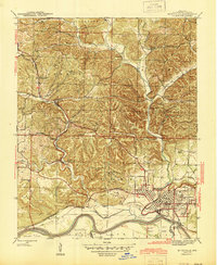
1942 Map of Batesville
USGS Topo · Published 1945About this map
Batesville serves as the focal point of this mid-century landscape, where the White River and the Missouri Pacific railroad converge to drive the local economy. The industrial character of the era is evident through specialized sites such as the Aydelotte Mine and the Miller-Rhinehart Washer, alongside the Scheid Quarry. These operations, connected by rail spurs and rural junctions like Limedale Junction and Cushman Junc, highlight a period of active resource extraction.
Find a feature on this map
66 named features on this map. Tap any name to fly to it.
Don’t see what you’re looking for? This feature index may not catch every label — zoom into the map to look around manually.
Map Details
Editions of this 1942 Batesville Map
2 editions found
Other maps of this area

1890 · Batesville
USGS Topo · 1:125,000

1891 · Batesville
USGS Topo · 1:125,000

1942 · Bethesda
USGS Topo · 1:24,000

1942 · Jamestown
USGS Topo · 1:31,680

1942 · Almond
USGS Topo · 1:31,680

1942 · Salado
USGS Topo · 1:31,680

1942 · Mt Pleasant
USGS Topo · 1:31,680

1943 · Sandtown
USGS Topo · 1:24,000

1943 · Cave City
USGS Topo · 1:31,680

1943 · Sulphur Rock
USGS Topo · 1:31,680