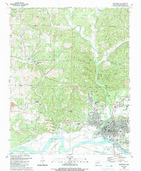
1989 Map of Batesville
USGS Topo · Published 1989About this map
Batesville sits at the confluence where Poke Bayou meets the White River, serving as a vital regional hub for education and industry in the late 1980s. The presence of Arkansas College and several educational institutions like Landmark Academy and Intermediate School underscore its role as an academic center. To the west, the landscape transitions from the urbanized riverfront to industrial sites and smaller settlements like Limedale and Cushman Junction.
Find a feature on this map
91 named features on this map. Tap any name to fly to it.
Don’t see what you’re looking for? This feature index may not catch every label — zoom into the map to look around manually.
Map Details
Editions of this 1989 Batesville Map
This is the sole edition of this map. No revisions or reprints were ever made.
Other maps of this area

1890 · Batesville
USGS Topo · 1:125,000

1891 · Batesville
USGS Topo · 1:125,000

1942 · Bethesda
USGS Topo · 1:24,000

1942 · Jamestown
USGS Topo · 1:31,680

1942 · Almond
USGS Topo · 1:31,680

1942 · Salado
USGS Topo · 1:31,680

1942 · Batesville
USGS Topo · 1:31,680

1942 · Mt Pleasant
USGS Topo · 1:31,680

1943 · Sandtown
USGS Topo · 1:24,000

1943 · Cave City
USGS Topo · 1:31,680