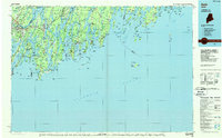
1985 Map of Bath
USGS Topo · Published 1986About this map
Bath and Brunswick anchor this Midcoast landscape at a time when maritime activity and military presence defined the regional economy. The massive footprint of the Brunswick Naval Air Station sits adjacent to the Maine Central RR, while the complex hydrology of Merrymeeting Bay marks the convergence of the Kennebec River and Androscoggin River. This map details the intricate archipelago of the Maine coast, from the narrow passages of Hell Gate and The Reach to the exposed outposts of Monhegan Plantation and the fishing villages of New Harbor and Port Clyde.
Find a feature on this map
339 named features on this map. Tap any name to fly to it.
Don’t see what you’re looking for? This feature index may not catch every label — zoom into the map to look around manually.
Map Details
Editions of this 1985 Bath Map
2 editions found
Other maps of this area

1892 · Gardiner
USGS Topo · 1:62,500

1892 · Freeport
USGS Topo · 1:62,500

1893 · Small Point
USGS Topo · 1:62,500

1893 · Casco Bay
USGS Topo · 1:62,500

1893 · Wiscasset
USGS Topo · 1:62,500

1893 · Boothbay
USGS Topo · 1:62,500

1894 · Bath
USGS Topo · 1:62,500

1904 · Vinalhaven
USGS Topo · 1:62,500

1904 · Monhegan
USGS Topo · 1:62,500

1904 · Tenants Harbor
USGS Topo · 1:62,500