
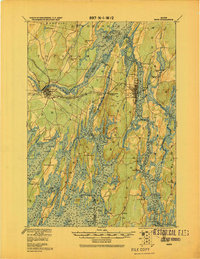
1920 Map of Bath
USGS Topo · Published 1920About this map
Merrymeeting Bay serves as the central focal point of this coastal landscape, where the Cathance River and Muddy River converge within a complex network of tidal inlets and islands. This military survey, compiled by the Corps of Engineers, details a maritime economy and transit hub at the height of the rail era. Extensive rail infrastructure is documented, including the M. C. R. R. and the Lewiston Brunswick & Bath Electric R. R., which linked the industrial centers of Bath and Brunswick to the surrounding countryside. Along the jagged coastline, the map identifies numerous small landings and island communities such as Orr Island, Cundy Harbor, and Phippsburg. Notable landmarks like the Quaker church and the Hospital in Bath provide specific points of interest for genealogical and local history research in this tidal region of Sagadahoc and Cumberland Counties.
Find a feature on this map
147 named features on this map. Tap any name to fly to it.
Don’t see what you’re looking for? This feature index may not catch every label — zoom into the map to look around manually.
Map Details
Editions of this 1920 Bath Map
2 editions found
Other maps of this area

1892 · Gardiner
USGS Topo · 1:62,500

1892 · Freeport
USGS Topo · 1:62,500

1893 · Small Point
USGS Topo · 1:62,500

1893 · Casco Bay
USGS Topo · 1:62,500

1893 · Wiscasset
USGS Topo · 1:62,500

1893 · Boothbay
USGS Topo · 1:62,500

1894 · Bath
USGS Topo · 1:62,500

1908 · Lewiston
USGS Topo · 1:62,500

1914 · Casco Bay
USGS Topo · 1:48,000

1916 · Casco Bay
USGS Topo · 1:62,500