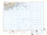
1965 Map of Bath
USGS Topo · Published 1965About this map
Coastal Maine’s complex network of estuaries and islands is revealed in this mid-1960s study, which traces the transition from the industrial hubs of Brunswick and Bath to the remote outposts of the Atlantic Ocean. The maritime character of the region is defined by the heavy presence of shipping and defense infrastructure, including the Fort Popham Military Res at the mouth of the Kennebec River and a U S Coast Guard Station managing the approaches to the Medomak River and Penobscot Bay. Further inland, the Maine Central RR connects the riverside towns of Topsham, Wiscasset, and Rockland. The map illustrates the era’s navigation patterns through the Two Bush Channel and past isolated landmasses like Monhegan Island and Matinicus Island, providing a detailed look at the granite-edged coastline before later 20th-century development altered these historic harbor settlements.
Find a feature on this map
55 named features on this map. Tap any name to fly to it.
Don’t see what you’re looking for? This feature index may not catch every label — zoom into the map to look around manually.
Map Details
Editions of this 1965 Bath Map
This is the sole edition of this map. No revisions or reprints were ever made.
Other maps of this area

1892 · Gardiner
USGS Topo · 1:62,500

1892 · Freeport
USGS Topo · 1:62,500

1893 · Small Point
USGS Topo · 1:62,500

1893 · Casco Bay
USGS Topo · 1:62,500

1893 · Wiscasset
USGS Topo · 1:62,500

1893 · Boothbay
USGS Topo · 1:62,500

1894 · Bath
USGS Topo · 1:62,500

1904 · Deer Isle
USGS Topo · 1:62,500

1904 · Swan Island
USGS Topo · 1:62,500

1904 · Vinalhaven
USGS Topo · 1:62,500