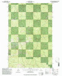
1995 Map of Bathtub Mountain
USGS Topo · Published 1997About this map
St Joe National Forest dominates this landscape in the northern Idaho Panhandle, where high ridgelines and deep creek drainages define the geography. Centered on Bathtub Mtn, the terrain is marked by prominent crests including Lightning Ridge and Surveyors Ridge, which separate the watersheds of Canyon Creek and Bluff Creek. The presence of Bathtub Meadows and Pineapple Spring suggests pockets of more level, watered ground amidst the otherwise steep slopes of the Bitterroot Range. While largely a wilderness area by the mid-1990s, human activity is evidenced by a Gravel Pit near the northern boundary and the network of forest trails or service roads indicated throughout the forest. This map captures the intricate drainage system of the St. Joe River basin, tracing countless named tributaries like Spotted Louis Creek and Pappose Creek as they descend from peaks such as Fortune Point and Junction Peak.
Find a feature on this map
32 named features on this map. Tap any name to fly to it.
Don’t see what you’re looking for? This feature index may not catch every label — zoom into the map to look around manually.
Map Details
Editions of this 1995 Bathtub Mountain Map
This is the sole edition of this map. No revisions or reprints were ever made.
Other maps of this area

1911 · Lolo
USGS Topo · 1:250,000

1913 · Lolo
USGS Topo · 1:250,000

1914 · Avery
USGS Topo · 1:125,000

1917 · Avery
USGS Topo · 1:125,000

1918 · St Regis
USGS Topo · 1:125,000

1919 · St. Regis
USGS Topo · 1:125,000

1923 · Washington Creek
USGS Topo · 1:125,000

1956 · Wallace
USGS Topo · 1:250,000

1956 · Hamilton
USGS Topo · 1:250,000

1957 · Simmons Peak
USGS Topo · 1:62,500