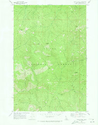
1969 Map of Bathtub Mtn
USGS Topo · Published 1973About this map
The St Joe National Forest dominates this high-altitude landscape in Idaho’s Shoshone County, where a intricate network of drainage systems defines the terrain. Recorded in the late 1960s, the map highlights the prominence of Bathtub Mtn and the adjacent Bathtub Meadows, which sit atop a significant Divide separating various mountain watersheds. The area is marked by a legacy of back-country access, visible through the numerous Pack Trails that connect peaks such as Sawtooth Peak, Junction Peak, and Canyon Peak. Water sources like Pineapple Spring and creeks such as Spotted Louis Creek and Lightning Creek are critical features in this wilderness environment. The inclusion of labels like Surveyors Ridge reflects the human history of mapping and managing these remote stretches of the Bitterroot range before modern road development was widespread.
Find a feature on this map
28 named features on this map. Tap any name to fly to it.
Don’t see what you’re looking for? This feature index may not catch every label — zoom into the map to look around manually.
Map Details
Editions of this 1969 Bathtub Mtn Map
This is the sole edition of this map. No revisions or reprints were ever made.
Other maps of this area

1911 · Lolo
USGS Topo · 1:250,000

1913 · Lolo
USGS Topo · 1:250,000

1914 · Avery
USGS Topo · 1:125,000

1917 · Avery
USGS Topo · 1:125,000

1918 · St Regis
USGS Topo · 1:125,000

1919 · St. Regis
USGS Topo · 1:125,000

1923 · Washington Creek
USGS Topo · 1:125,000

1956 · Wallace
USGS Topo · 1:250,000

1956 · Hamilton
USGS Topo · 1:250,000

1957 · Simmons Peak
USGS Topo · 1:62,500