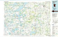
1986 Map of Battle Lake
USGS Topo · Published 1986About this map
Otter Tail Lake and the vast network of glacial basins define this mid-1980s landscape at the heart of West Central Minnesota's lake country. This survey illustrates the intricate water systems where the Otter Tail River and Leaf River originate, showing how the terrain transitions near the prominent Leaf Mountain and Black Peak. The map provides a detailed view of established communities like Wadena, Parkers Prairie, and the village of Battle Lake, all situated within a matrix of agricultural sections and protected lands.
Find a feature on this map
75 named features on this map. Tap any name to fly to it.
Don’t see what you’re looking for? This feature index may not catch every label — zoom into the map to look around manually.
Map Details
Editions of this 1986 Battle Lake Map
2 editions found
Other maps of this area

1910 · Wendell
USGS Topo · 1:62,500

1911 · Barrett
USGS Topo · 1:62,500

1911 · Herman
USGS Topo · 1:62,500

1912 · Vergas
USGS Topo · 1:62,500

1912 · Battle Lake
USGS Topo · 1:62,500

1913 · Ashby
USGS Topo · 1:62,500

1913 · Fergus Falls
USGS Topo · 1:62,500

1913 · Wendell
USGS Topo · 1:62,500

1914 · Battle Lake
USGS Topo · 1:62,500

1914 · Pelican Rapids
USGS Topo · 1:62,500