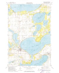
1973 Map of Battle Lake
USGS Topo · Published 1975About this map
West Battle Lake and Clitherall Lake dominate this glaciated landscape of central Minnesota, where the lake-heavy terrain of Everts and Clitherall townships is shown in detail. The settlement of Battle Lake serves as a local hub, situated between its namesake waters and Elbow Lake. Transportation and industry are defined by the Burlington Northern railroad corridor and the Battle Lake Municipal Airport. Local heritage is preserved in numerous scattered burial grounds, including Lakewood Cem, Trinity Cem, and Skibvedt Cem. Further south, the village of Clitherall sits at the eastern edge of the map near the northern shore of its own namesake lake. The map also identifies specific local infrastructure such as a Fish Farm, several Gravel Pits, and a National Waterfowl Production Area, reflecting the area's mix of natural resource management and recreational water access.
Find a feature on this map
37 named features on this map. Tap any name to fly to it.
Don’t see what you’re looking for? This feature index may not catch every label — zoom into the map to look around manually.
Map Details
Editions of this 1973 Battle Lake Map
This is the sole edition of this map. No revisions or reprints were ever made.
Other maps of this area

1912 · Battle Lake
USGS Topo · 1:62,500

1913 · Ashby
USGS Topo · 1:62,500

1914 · Battle Lake
USGS Topo · 1:62,500

1915 · Underwood
USGS Topo · 1:62,500

1953 · Brainerd
USGS Topo · 1:250,000

1957 · Brainerd
USGS Topo · 1:250,000

1958 · Brainerd
USGS Topo · 1:250,000

1965 · Brainerd
USGS Topo · 1:250,000

1969 · Eagle Lake
USGS Topo · 1:24,000
1969 · Inspiration Peak
USGS Topo · 1:24,000