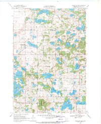
1969 Map of Inspiration Peak
USGS Topo · Published 1971About this map
Inspiration Peak rises as a prominent landmark in this glacial landscape of Otter Tail County, surveyed in 1969. The terrain is characterized by a dense concentration of small water bodies, including Ellingson Lake, Siverson Lake, and Trulson Lake, reflecting the region's complex post-glacial geology. The township boundaries of Nidaros, Folden, and Effington meet in this area, which remained largely rural and focused on conservation and small-scale agriculture at the time of this mapping. Local community life is anchored by landmarks like the Leaf Mountain Ch and the Townhall, while public land use is represented by several National Wildlife Management Areas and the Inspiration Peak State Wayside Park. The presence of multiple Gravel Pits underscores the local extraction of glacial materials used for regional infrastructure.
Find a feature on this map
28 named features on this map. Tap any name to fly to it.
Don’t see what you’re looking for? This feature index may not catch every label — zoom into the map to look around manually.
Map Details
Editions of this 1969 Inspiration Peak Map
This is the sole edition of this map. No revisions or reprints were ever made.
Other maps of this area

1912 · Battle Lake
USGS Topo · 1:62,500

1914 · Battle Lake
USGS Topo · 1:62,500

1953 · Brainerd
USGS Topo · 1:250,000

1957 · Brainerd
USGS Topo · 1:250,000

1958 · Brainerd
USGS Topo · 1:250,000

1965 · Brainerd
USGS Topo · 1:250,000
1969 · Lake Miltona West
USGS Topo · 1:24,000

1969 · Henning
USGS Topo · 1:24,000

1969 · Eagle Lake
USGS Topo · 1:24,000
1969 · Parkers Prairie NW
USGS Topo · 1:24,000