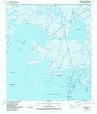
1993 Map of Bay Batiste
USGS Topo · Published 1994About this map
The coastal wetlands of Plaquemines Parish appear as a complex network of marshes and industrial infrastructure in this early 1990s record. At the southern edge of the sheet, Grande Ecaille serves as a focal point for the region's extraction history, dominated by the Freeport Sulphur Co Elevated Pipeline and an extensive Oil and Gas field. These man-made structures contrast sharply with the fluid geography of Bay Batiste and Barataria Bay, where the land is constantly reshaped by the surrounding waters.
Find a feature on this map
34 named features on this map. Tap any name to fly to it.
Don’t see what you’re looking for? This feature index may not catch every label — zoom into the map to look around manually.
Map Details
Editions of this 1993 Bay Batiste Map
This is the sole edition of this map. No revisions or reprints were ever made.
Other maps of this area

1891 · Pointe a La Hache
USGS Topo · 1:62,500

1892 · Quarantine
USGS Topo · 1:62,500

1892 · Pointe a La Hache
USGS Topo · 1:62,500

1893 · Fort Livingston
USGS Topo · 1:62,500

1893 · Dime
USGS Topo · 1:62,500

1935 · Port Sulphur
USGS Topo · 1:31,680

1935 · Bastian Bay
USGS Topo · 1:31,680

1935 · Bay Ronquille
USGS Topo · 1:31,680

1935 · Wilkinson Bay
USGS Topo · 1:31,680

1939 · Pointe a La Hache
USGS Topo · 1:62,500