1939 Map of Pointe a La Hache
USGS Topo · Published 1941About this map
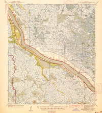
The Mississippi River defines the geography of Plaquemines Parish in the late 1930s, its winding course lined with riverfront settlements and a dense network of drainage infrastructure. This survey captures a specific era of South Louisiana's coastal landscape, where narrow strips of habitable land like Wilkinson Ridge are surrounded by extensive marsh systems and named water bodies such as Lake Hermitage and Round Lake. The settlement pattern follows the river's natural levees, featuring established communities from Belair down to Bohemia and Foster.
Find a feature on this map
112 named features on this map. Tap any name to fly to it.
Don’t see what you’re looking for? This feature index may not catch every label — zoom into the map to look around manually.
Map Details
Editions of this 1939 Pointe a La Hache Map
2 editions found

Other maps of this area

1891 · Pointe a La Hache
USGS Topo · 1:62,500

1891 · New Orleans
USGS Topo · 1:62,500

1892 · Barataria
USGS Topo · 1:62,500

1892 · Quarantine
USGS Topo · 1:62,500

1892 · Creole
USGS Topo · 1:62,500

1892 · St. Bernard
USGS Topo · 1:62,500

1892 · Pointe a La Hache
USGS Topo · 1:62,500

1893 · Shell Beach
USGS Topo · 1:62,500

1893 · Fort Livingston
USGS Topo · 1:62,500

1893 · Dime
USGS Topo · 1:62,500