
1939 Map of Pointe a La Hache
USGS Topo · Published 1954About this map
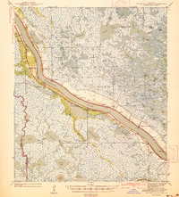
Mississippi River levees and the intricate bayous of Plaquemines Parish define this 1939 survey, capturing a riverine economy dependent on both water and rail. The east bank is anchored by Pointe a la Hache, the regional center connected by the Louisiana Southern railroad to downstream settlements like Bohemia and City Price. Across the water, the Missouri Pacific line services a string of communities including Myrtle Grove, Alliance, and Burbridge.
Find a feature on this map
109 named features on this map. Tap any name to fly to it.
Don’t see what you’re looking for? This feature index may not catch every label — zoom into the map to look around manually.
Map Details
Editions of this 1939 Pointe a La Hache Map
2 editions found
Other maps of this area

1891 · Pointe a La Hache
USGS Topo · 1:62,500

1891 · New Orleans
USGS Topo · 1:62,500

1892 · Barataria
USGS Topo · 1:62,500

1892 · Quarantine
USGS Topo · 1:62,500

1892 · Creole
USGS Topo · 1:62,500

1892 · St. Bernard
USGS Topo · 1:62,500

1892 · Pointe a La Hache
USGS Topo · 1:62,500

1893 · Shell Beach
USGS Topo · 1:62,500

1893 · Fort Livingston
USGS Topo · 1:62,500

1893 · Dime
USGS Topo · 1:62,500