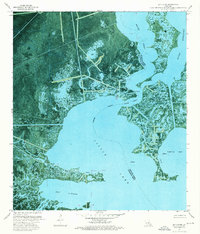
1973 Map of Bay L'ours
USGS Topo · Published 1976About this map
Little Lake and the surrounding marshlands of south Louisiana are captured here as they appeared in the early 1970s, defined by a complex network of waterways and industrial development. This orthophotomap, produced by the U.S. Geological Survey using aerial photography from 1971, reveals the intricate relationship between the natural landscape and the energy sector. Evidence of industry is scattered throughout the wetlands, notably in the Little Temple Oil and Gas Field and the Little Lake Oil and Gas Field. A series of canals, pipelines, and numerous drill holes crisscross the terrain, showing how the search for resources reshaped the delta. The sheet also documents the indefinite boundary between Jefferson and Lafourche Parishes, winding through open water like Bayou Rigolettes and Bay L'ours, where traditional landmarks are replaced by offshore structures and navigation lights.
Find a feature on this map
19 named features on this map. Tap any name to fly to it.
Don’t see what you’re looking for? This feature index may not catch every label — zoom into the map to look around manually.
Map Details
Editions of this 1973 Bay L'ours Map
This is the sole edition of this map. No revisions or reprints were ever made.
Other maps of this area

1892 · Barataria
USGS Topo · 1:62,500

1892 · Cut-Off
USGS Topo · 1:62,500

1892 · Creole
USGS Topo · 1:62,500

1894 · Lake Felicity
USGS Topo · 1:62,500

1935 · Golden Meadow
USGS Topo · 1:31,680

1939 · Cut-Off
USGS Topo · 1:62,500

1939 · Lake Felicity
USGS Topo · 1:62,500

1941 · Cut-Off
USGS Topo · 1:62,500

1941 · Lake Felicity
USGS Topo · 1:62,500

1941 · Barataria
USGS Topo · 1:62,500