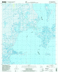
1998 Map of Bay L'Ours
USGS Topo · Published 2002About this map
Little Temple Oil and Gas Field dominates the central portion of this 1990s coastal landscape, where the shifting boundaries of Jefferson and Lafourche Parishes meet amidst a network of canals and pipelines. The environment is defined by extensive wetlands and open water, notably Little Lake and Bay L'Ours, which are bisected by an Indefinite Boundary reflecting the dynamic nature of the Louisiana shoreline. Industrial activity is woven into the geography through scattered Oil Wells, Drill Holes, and offshore Platforms that support the local energy economy. Navigational markers like the Light near the southern shore and the Harvey Cutoff channel provide essential orientation for maritime transit between Bayou Perot and Turtle Bay.
Find a feature on this map
16 named features on this map. Tap any name to fly to it.
Don’t see what you’re looking for? This feature index may not catch every label — zoom into the map to look around manually.
Map Details
Editions of this 1998 Bay L'Ours Map
This is the sole edition of this map. No revisions or reprints were ever made.
Other maps of this area

1892 · Barataria
USGS Topo · 1:62,500

1892 · Cut-Off
USGS Topo · 1:62,500

1892 · Creole
USGS Topo · 1:62,500

1894 · Lake Felicity
USGS Topo · 1:62,500

1935 · Golden Meadow
USGS Topo · 1:31,680

1939 · Cut-Off
USGS Topo · 1:62,500

1939 · Lake Felicity
USGS Topo · 1:62,500

1941 · Cut-Off
USGS Topo · 1:62,500

1941 · Lake Felicity
USGS Topo · 1:62,500

1941 · Barataria
USGS Topo · 1:62,500