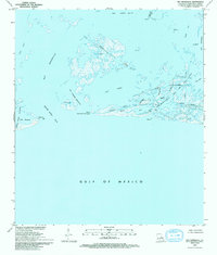
1993 Map of Bay Ronquille
USGS Topo · Published 1994About this map
Industrial activity and coastal erosion patterns intersect at Lake Washington and Bay Ronquille in this late-twentieth-century study of the Plaquemines Parish shoreline. The landscape is dominated by a complex network of man-made features, including an Elevated Pipeline and numerous Platforms that mark the intensive resource extraction typical of the region. Navigational markers like Quatre 2 Light at Quatre Bayou Pass guide traffic through the shifting barrier islands and bays.
Find a feature on this map
28 named features on this map. Tap any name to fly to it.
Don’t see what you’re looking for? This feature index may not catch every label — zoom into the map to look around manually.
Map Details
Editions of this 1993 Bay Ronquille Map
This is the sole edition of this map. No revisions or reprints were ever made.
Other maps of this area

1892 · Quarantine
USGS Topo · 1:62,500

1893 · Fort Livingston
USGS Topo · 1:62,500

1935 · Port Sulphur
USGS Topo · 1:31,680

1935 · Bastian Bay
USGS Topo · 1:31,680

1935 · Bay Ronquille
USGS Topo · 1:31,680

1935 · Wilkinson Bay
USGS Topo · 1:31,680

1941 · Empire
USGS Topo · 1:62,500

1944 · Empire
USGS Topo · 1:62,500

1947 · Bay Ronquille
USGS Topo · 1:31,680
1947 · Wilkinson Bay
USGS Topo · 1:31,680