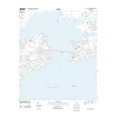
2012 Map of Bay Saint Louis
USGS Topo · Published 2012About this map
Saint Louis Bay dominates this coastal landscape, separating the developed shorelines of Bay Saint Louis and Pass Christian Isles during the early 21st century. The map illustrates the region's recovery and modern infrastructure, centered on the expansive Bay Saint Louis Bridge that reconnects the two peninsulas. Residential growth is evident in communities like Timber Ridge and near the Diamondhead Marina, while recreational facilities such as the Casino Magic Recreational Vehicle Park and Francis McDonald Stadium reflect the area's maritime and community character.
Find a feature on this map
26 named features on this map. Tap any name to fly to it.
Don’t see what you’re looking for? This feature index may not catch every label — zoom into the map to look around manually.
Map Details
Editions of this 2012 Bay Saint Louis Map
This is the sole edition of this map. No revisions or reprints were ever made.
Other maps of this area

1893 · Cat Island
USGS Topo · 1:62,500

1893 · Toulme
USGS Topo · 1:62,500

1935 · Grand Island Pass
USGS Topo · 1:31,680

1946 · Isle Au Pitre
USGS Topo · 1:31,680

1949 · Grand Island Pass
USGS Topo · 1:31,680

1953 · Mobile
USGS Topo · 1:250,000

1954 · Isle Au Pitre
USGS Topo · 1:31,680

1955 · Pass Christian
USGS Topo · 1:24,000
1955 · Isle Au Pitre
USGS Topo · 1:24,000

1956 · Bay St. Louis
USGS Topo · 1:24,000