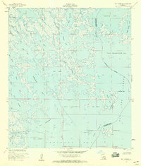
1956 Map of Bay Tambour
USGS Topo · Published 1959About this map
Southwestern Louisiana Canal cuts through the marshy transition between Lafourche and Jefferson Parishes in this mid-1950s survey. The landscape is a complex network of coastal inlets and bayous, where land is more of a suggestion than a permanent fixture, characterized by points like Martigan Point and isolated landmasses such as Andre Island. The maritime economy and early industrial footprint are evident through scattered Oil Wells and navigational Lights that guided vessels through the intricate waterways of Bay Tambour and Caminada Bay. These interior waters, including Fishermans Bay and Des Ilettes Bay, show the area's historical reliance on water-based transit before significant modern coastal erosion altered these shorelines. The map preserves the specific locations of bayous like Palmetto Bayou and Bayou Casse-Tete as they existed during a period of expanding offshore activity.
Find a feature on this map
36 named features on this map. Tap any name to fly to it.
Don’t see what you’re looking for? This feature index may not catch every label — zoom into the map to look around manually.
Map Details
Editions of this 1956 Bay Tambour Map
3 editions found
Other maps of this area

1892 · Cheniere Caminada
USGS Topo · 1:62,500

1892 · Creole
USGS Topo · 1:62,500

1893 · Fort Livingston
USGS Topo · 1:62,500

1935 · Mink Bayou
USGS Topo · 1:31,680

1935 · Leeville
USGS Topo · 1:31,680

1935 · Wilkinson Bay
USGS Topo · 1:31,680

1945 · New Orleans
USGS Topo · 1:250,000

1945 · Leeville
USGS Topo · 1:31,680
1946 · Mink Bayou
USGS Topo · 1:31,680

1947 · Caminada Pass
USGS Topo · 1:31,680