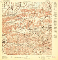
1950 Map of Bayamon SO
USGS Topo · Published 1950About this map
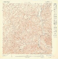
Toa Alta serves as a focal point at the southwestern edge of this 1950 topographic survey, where the winding course of the Rio de la Plata meets the rugged interior hills. The landscape reflects a mix of agricultural and strategic development, prominently featuring the Reservacion Naval and several agricultural colonies such as Colonia Campanilla and Colonia Las Arenas. These settlements, along with Sabana Seca and Hato Tejas, are connected by a network of roads and a prominent Linea de Transmision that cuts across the central terrain. The intricate drainage system of the region is well-documented through numerous named waterways, including the Rio Bucarabones, Quebrada Mameyes, and Quebrada Santa Catalina. Local community life is anchored by landmarks like the Iglesia Evangelica and Iglesia Cristo Rey, providing specific points of interest for genealogical research into the mid-century families of these barrios.
Find a feature on this map
31 named features on this map. Tap any name to fly to it.
Don’t see what you’re looking for? This feature index may not catch every label — zoom into the map to look around manually.
Map Details
Editions of this 1950 Bayamon SO Map
This is the sole edition of this map. No revisions or reprints were ever made.
Other maps of this area

1940 · Vega Alta
USGS Topo · 1:30,000

1941 · Bayamon
USGS Topo · 1:30,000

1946 · Corozal
USGS Topo · 1:30,000

1946 · Vega Alta
USGS Topo · 1:30,000

1946 · Naranjito
USGS Topo · 1:30,000
1947 · Corozal NE
USGS Topo · 1:10,000
1947 · Bayamon
USGS Topo · 1:30,000
1947 · Naranjito NO
USGS Topo · 1:10,000
1947 · Naranjito NE
USGS Topo · 1:10,000
1950 · Bayamon NE
USGS Topo · 1:10,000