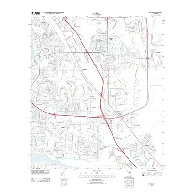
2012 Map of Bayard
USGS Topo · Published 2012About this map
Julington Creek and its many winding tributaries, including Durbin Cr and Big Davis Cr, define the southern geography of this Jacksonville landscape. Historically significant communities like Loretto and Bayard anchor the region, illustrating the evolution of south Duval County from rural outposts to developing suburban centers. The map highlights the intersection of commerce and local history, featuring the Saint Joseph Cem and the Hood Public Landing along the waterfront. Residential development is evident in neighborhoods such as Sunbeam, San Jose, and the Deerwood Club. The intricate drainage network, shown through labels like Cormorant Br and Sweetwater Cr, reveals the low-lying, water-dependent nature of the Florida terrain. Large-scale modern infrastructure, such as the Shoppes of Baymeadows, stands alongside older place names like Goodbys and Greenland.
Find a feature on this map
152 named features on this map. Tap any name to fly to it.
Don’t see what you’re looking for? This feature index may not catch every label — zoom into the map to look around manually.
Map Details
Editions of this 2012 Bayard Map
This is the sole edition of this map. No revisions or reprints were ever made.
Other maps of this area

1917 · Orange Park
USGS Topo · 1:62,500

1918 · Jacksonville
USGS Topo · 1:62,500

1918 · Orange Park
USGS Topo · 1:62,500

1918 · Palm Valley
USGS Topo · 1:62,500

1918 · Mayport
USGS Topo · 1:62,500

1948 · Jacksonville
USGS Topo · 1:250,000

1948 · Jacksonville Beach
USGS Topo · 1:24,000

1949 · Jacksonville Beach
USGS Topo · 1:24,000

1950 · Arlington
USGS Topo · 1:24,000
1950 · Jacksonville
USGS Topo · 1:24,000
Featured Places
- Jacksonville, FL
- Greenland, Jacksonville
- Wesley Manor Retirement Village, FL
- San Jose, Jacksonville
- Stockade, Jacksonville