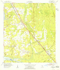
1952 Map of Bayard
USGS Topo · Published 1956About this map
The St Johns River defines the western edge of this early 1950s survey, where the riverbank meets a landscape dominated by expansive wetlands like Tiger Hole Swamp and Big Island Swamp. This era shows the Florida East Coast railroad and the parallel Florida East Coast (U.S. 1) highway serving as the primary corridor for settlements like Bayard and Sunbeam. Local life is anchored by institutions such as St Josephs Academy and the Loretto-Mandarin Sch, while the southern boundary follows the winding course of Julington Creek. The interior terrain is a network of drainage branches, including Second Puncheon Branch and Mill Dam Branch, illustrating the complex hydrology that influenced development patterns in Duval County before widespread suburban expansion altered the local drainage and land use.
Find a feature on this map
40 named features on this map. Tap any name to fly to it.
Don’t see what you’re looking for? This feature index may not catch every label — zoom into the map to look around manually.
Map Details
Editions of this 1952 Bayard Map
This is the sole edition of this map. No revisions or reprints were ever made.
Other maps of this area

1917 · Orange Park
USGS Topo · 1:62,500

1918 · Jacksonville
USGS Topo · 1:62,500

1918 · Orange Park
USGS Topo · 1:62,500

1918 · Palm Valley
USGS Topo · 1:62,500

1918 · Mayport
USGS Topo · 1:62,500

1948 · Jacksonville
USGS Topo · 1:250,000

1948 · Jacksonville Beach
USGS Topo · 1:24,000

1949 · Jacksonville Beach
USGS Topo · 1:24,000

1950 · Arlington
USGS Topo · 1:24,000
1950 · Jacksonville
USGS Topo · 1:24,000
Featured Places
- Jacksonville, FL
- Greenland, Jacksonville
- San Jose, Jacksonville
- Bayard, Jacksonville
- Stockade, Jacksonville