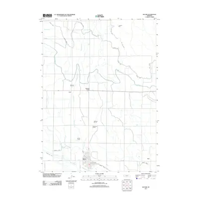
2011 Map of Bayard
USGS Topo · Published 2011About this map
Bayard serves as the primary hub in this Nebraska landscape, characterized by a complex network of man-made waterways designed for large-scale agricultural irrigation. The town's layout is centered near the Bayard Post Office and Ninemile Canal, which works in tandem with the Short Line Canal to manage the region's water resources. This intricate system of infrastructure is further evidenced by features like Wildhorse Dam 14-A and Wildhorse Dam 5-A, which help control the Wildhorse Drain as it moves toward the Tri-State Canal. To the north and west, the terrain transitions toward Wildhorse Canyon and smaller settlements such as Moomaw Corner and Craft. The presence of the Chimney Rock Golf Course and recreational points like Davidson Dam reflects the modern development of this rural corridor along the North Platte River valley.
Find a feature on this map
30 named features on this map. Tap any name to fly to it.
Don’t see what you’re looking for? This feature index may not catch every label — zoom into the map to look around manually.
Map Details
Editions of this 2011 Bayard Map
This is the sole edition of this map. No revisions or reprints were ever made.
Other maps of this area

1898 · Camp Clarke
USGS Topo · 1:125,000

1954 · Scottsbluff
USGS Topo · 1:250,000

1958 · Scottsbluff
USGS Topo · 1:250,000

1965 · Bayard
USGS Topo · 1:24,000

1965 · Bridgeport NW
USGS Topo · 1:24,000
1965 · Bayard NE
USGS Topo · 1:24,000

1965 · South Bayard
USGS Topo · 1:24,000
1965 · Angora NW
USGS Topo · 1:24,000

1965 · Bayard SW
USGS Topo · 1:24,000
1965 · Angora
USGS Topo · 1:24,000