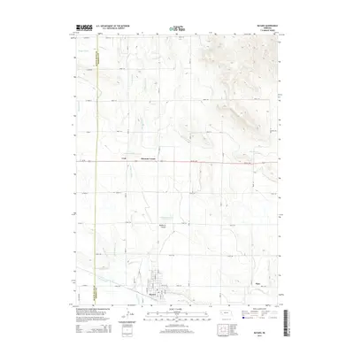
2014 Map of Bayard
USGS Topo · Published 2014About this map
Bayard serves as the focal point of this irrigation-focused landscape, situated at the junction of Us-26 and Ne-62a-Link. The town’s layout includes named thoroughfares like Main St and Avenue A, reflecting its role as a regional hub. The surrounding terrain is defined by a sophisticated water management network, essential for high-plains agriculture. Major arteries like the Tri-State Canal and Ninemile Canal traverse the area, while the Wildhorse Reservoir and Davidson Reservoir provide critical water storage. Smaller communities and rural intersections such as Craft, Moomaw Corner, and Piper punctuate the grid of county roads. The landscape transitions from the flat, canal-fed basins to the topographical relief of Wildhorse Canyon, highlighting the geological variety along the Scotts Bluff and Morrill County line.
Find a feature on this map
46 named features on this map. Tap any name to fly to it.
Don’t see what you’re looking for? This feature index may not catch every label — zoom into the map to look around manually.
Map Details
Editions of this 2014 Bayard Map
This is the sole edition of this map. No revisions or reprints were ever made.
Other maps of this area

1898 · Camp Clarke
USGS Topo · 1:125,000

1954 · Scottsbluff
USGS Topo · 1:250,000

1958 · Scottsbluff
USGS Topo · 1:250,000

1965 · Bayard
USGS Topo · 1:24,000

1965 · Bridgeport NW
USGS Topo · 1:24,000
1965 · Bayard NE
USGS Topo · 1:24,000

1965 · South Bayard
USGS Topo · 1:24,000
1965 · Angora NW
USGS Topo · 1:24,000

1965 · Bayard SW
USGS Topo · 1:24,000
1965 · Angora
USGS Topo · 1:24,000