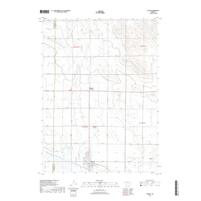
2017 Map of Bayard
USGS Topo · Published 2017About this map
Bayard stands as the central hub of this agricultural landscape in the Nebraska panhandle, where the boundary between Scotts Bluff and Morrill counties meets. The terrain is defined by a sophisticated water management network essential to High Plains farming, featuring the Tri-State Canal, Ninemile Canal, and the High-line Canal. These man-made waterways, alongside drainage systems like the Wildhorse Drain and Moffat Drain, illustrate the intensive engineering required to sustain the local economy.
Find a feature on this map
46 named features on this map. Tap any name to fly to it.
Don’t see what you’re looking for? This feature index may not catch every label — zoom into the map to look around manually.
Map Details
Editions of this 2017 Bayard Map
This is the sole edition of this map. No revisions or reprints were ever made.
Other maps of this area

1898 · Camp Clarke
USGS Topo · 1:125,000

1954 · Scottsbluff
USGS Topo · 1:250,000

1958 · Scottsbluff
USGS Topo · 1:250,000

1965 · Bayard
USGS Topo · 1:24,000

1965 · Bridgeport NW
USGS Topo · 1:24,000
1965 · Bayard NE
USGS Topo · 1:24,000

1965 · South Bayard
USGS Topo · 1:24,000
1965 · Angora NW
USGS Topo · 1:24,000

1965 · Bayard SW
USGS Topo · 1:24,000
1965 · Angora
USGS Topo · 1:24,000