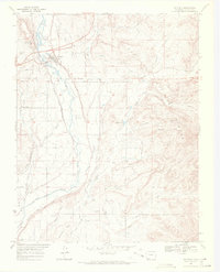
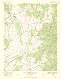
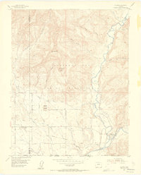
1968 Map of Bayfield
USGS Topo · Published 1972About this map
The Los Pinos River valley defines this high-altitude agricultural landscape, where the town of Bayfield serves as a hub for the surrounding ranching and irrigation systems. Sophisticated water management is evident through an extensive network of gravity-fed infrastructure, including the King Consolidated Ditch, Pine River Canal, and the Spring Creek Extension Ditch. These channels transformed the arid terrain between Shellhammer Ridge and the San Juan National Forest into productive land.
Find a feature on this map
47 named features on this map. Tap any name to fly to it.
Don’t see what you’re looking for? This feature index may not catch every label — zoom into the map to look around manually.
Map Details
Editions of this 1968 Bayfield Map
2 editions found
Other maps of this area

1908 · Ignacio
USGS Topo · 1:125,000

1924 · Ignacio
USGS Topo · 1:125,000

1924 · Pagosa Springs
USGS Topo · 1:125,000

1927 · Pagosa Springs
USGS Topo · 1:125,000

1945 · Durango
USGS Topo · 1:250,000

1953 · Durango
USGS Topo · 1:250,000

1954 · Durango
USGS Topo · 1:250,000
1954 · Allison
USGS Topo · 1:24,000

1961 · Durango
USGS Topo · 1:250,000

1963 · Durango
USGS Topo · 1:250,000