1968 Map of Bayfield
USGS Topo · Published 1972About this map
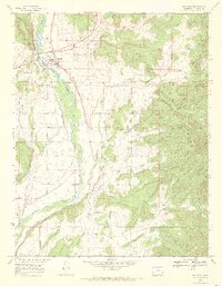
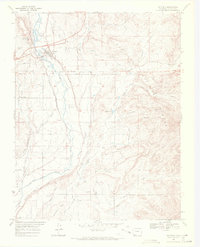
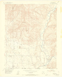
The town of Bayfield and the neighboring agricultural settlements of Missouri Center and Armstrong define the cultural landscape of this 1968 study. Situated along the Los Pinos River (also labeled here as the Pine River), the region shows a complex network of water management essential for high-altitude farming, including the Pine River Canal, King Consolidated Ditch, and Morrison Consolidated Ditch. This intricate system of ditches and siphons underscores the area's transition from the river valley to the elevated San Juan National Forest terrain in the east.
Find a feature on this map
54 named features on this map. Tap any name to fly to it.
Don’t see what you’re looking for? This feature index may not catch every label — zoom into the map to look around manually.
Map Details
Editions of this 1968 Bayfield Map
2 editions found
Other maps of this area

1908 · Ignacio
USGS Topo · 1:125,000

1924 · Ignacio
USGS Topo · 1:125,000

1924 · Pagosa Springs
USGS Topo · 1:125,000

1927 · Pagosa Springs
USGS Topo · 1:125,000

1945 · Durango
USGS Topo · 1:250,000

1953 · Durango
USGS Topo · 1:250,000

1954 · Durango
USGS Topo · 1:250,000
1954 · Allison
USGS Topo · 1:24,000

1961 · Durango
USGS Topo · 1:250,000

1963 · Durango
USGS Topo · 1:250,000