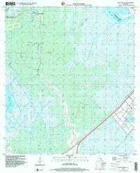
1998 Map of Bayou Boeuf
USGS Topo · Published 2000About this map
Bayou Boeuf (Kraemer PO) serves as the primary settlement node in this wetland landscape, where the human footprint is defined by narrow ridges and an extensive network of waterways. The community is anchored by St Lawrence Ch and a nearby Cem, situated along the natural levees that provide rare stable ground. To the south, the environment shifts toward the open waters of Lake Boeuf, while the surrounding marsh is segmented by an industrial infrastructure of dredging and extraction. This is evidenced by the Boeuf Gas Field and numerous labels for Gas Wells and Pipelines. The drainage pattern is a complex mix of natural bayous like Pistolet Bayou and Rond Pompon Bayou and straight-line cuts such as the Midway Canal. This late 20th-century survey illustrates the persistent tension between the original Cajun settlement patterns and the evolving energy economy of the gulf coast.
Find a feature on this map
22 named features on this map. Tap any name to fly to it.
Don’t see what you’re looking for? This feature index may not catch every label — zoom into the map to look around manually.
Map Details
Editions of this 1998 Bayou Boeuf Map
This is the sole edition of this map. No revisions or reprints were ever made.
Other maps of this area

1891 · Hahnville
USGS Topo · 1:62,500

1892 · Lac Des Allemands
USGS Topo · 1:62,500

1892 · Cut-Off
USGS Topo · 1:62,500

1892 · Houma
USGS Topo · 1:62,500

1932 · Lac Des Allemands NW
USGS Topo · 1:31,680

1932 · Lac Des Allemands SE
USGS Topo · 1:31,680

1932 · Lac Des Allemands SW
USGS Topo · 1:31,680

1932 · Houma NE
USGS Topo · 1:31,680

1932 · Houma NW
USGS Topo · 1:31,680

1932 · Hahnville NW
USGS Topo · 1:31,680