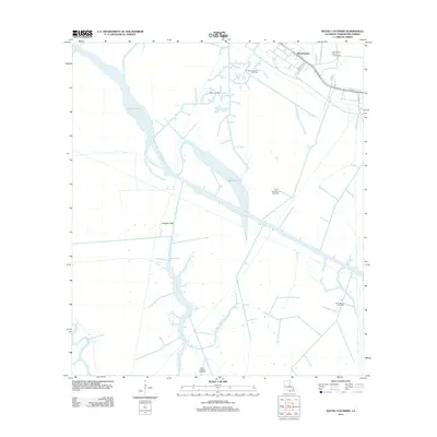
2012 Map of Bayou Cocodrie
USGS Topo · Published 2012About this map
Greenwood sits at the northern edge of this Louisiana delta landscape, where the terrestrial terrain begins its transition into the vast hydrologic network of Terrebonne Parish. The area is defined by a dense industrial infrastructure of energy extraction, featuring the Northeast Gibson Oil Field, Gibson Oil Field, and the East Gibson Gas and Oil Field. This network of wells and access points is woven through a complex system of natural and engineered waterways, including the broad reaches of Lake Cocodrie and Lake Hackberry. These water bodies are connected by a grid of transit canals like the Copasaw Canal and Huth Canal, which supplement the winding natural paths of Bayou Copasaw and Bayou Penchant. The map reveals how the modern energy economy has reshaped the marshland, utilizing every stretch of navigable water and level ground to support gas fields like the South Humphreys Gas Field and Saint Bayou Gas Field.
Find a feature on this map
22 named features on this map. Tap any name to fly to it.
Don’t see what you’re looking for? This feature index may not catch every label — zoom into the map to look around manually.
Map Details
Editions of this 2012 Bayou Cocodrie Map
This is the sole edition of this map. No revisions or reprints were ever made.
Other maps of this area

1892 · Gibson
USGS Topo · 1:62,500

1894 · Bayou De Large
USGS Topo · 1:62,500

1897 · Gibson
USGS Topo · 1:62,500

1932 · Lake Decade
USGS Topo · 1:62,500

1935 · Theriot
USGS Topo · 1:31,680

1935 · Morgan City
USGS Topo · 1:62,500

1935 · Lake Penchant
USGS Topo · 1:31,680

1939 · Gibson
USGS Topo · 1:62,500

1940 · Bayou Du Large
USGS Topo · 1:62,500

1941 · Bayou Du Large
USGS Topo · 1:62,500