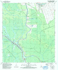
1992 Map of Bayou Sorrel
USGS Topo · Published 1992About this map
Bayou Sorrel sits at a critical junction of water and industry within the Iberville Parish wetlands, where the Gulf Intracoastal Waterway meets the Lower Grand River. This 1990s-era landscape is defined by the massive infrastructure of the Atchafalaya Basin Floodway and its accompanying Protection Levee, designed to manage the region's complex hydrology. The settlement pattern follows the higher ground along the bayous, evidenced by clusters of spiritual life like St Catherine Laboure Ch and Beam of Life Ch. Economic activity is driven by extensive energy extraction, with the Sullivan Lake Oil and Gas Field and Crescent Oil Field dominating the interior. Traces of earlier transit survive in the Old RR Grade and the Indian Mound Cem, providing a window into the long-standing human presence among the crawfish ponds and bottomlands.
Find a feature on this map
50 named features on this map. Tap any name to fly to it.
Don’t see what you’re looking for? This feature index may not catch every label — zoom into the map to look around manually.
Map Details
Editions of this 1992 Bayou Sorrel Map
This is the sole edition of this map. No revisions or reprints were ever made.
Other maps of this area

1908 · Baton Rouge
USGS Topo · 1:62,500

1935 · Chicot Lake
USGS Topo · 1:62,500

1936 · White Castle
USGS Topo · 1:62,500

1939 · Baton Rouge
USGS Topo · 1:62,500

1940 · Grosse Tete
USGS Topo · 1:62,500

1953 · Crescent
USGS Topo · 1:24,000

1953 · Plaquemine
USGS Topo · 1:24,000

1953 · Pigeon Bay
USGS Topo · 1:24,000

1953 · Addis
USGS Topo · 1:24,000

1953 · Grosse Tete SW
USGS Topo · 1:24,000