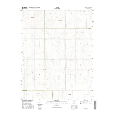
2015 Map of Bazine SE
USGS Topo · Published 2015About this map
Pawnee County, Kansas, meets its neighboring jurisdictions in this 2015 topographical study, defined by the precise intersections of the Public Land Survey System. The landscape is characterized by a network of rural routes including Alexander Rd and Correction Line Rd, which segment the agricultural terrain of western Kansas. This map details the meeting points of four counties, highlighting the Ness Co Rush Co and Hodgeman Co Pawnee Co boundaries. Significant for local research, the map traces the CR 100 Ness Ct Line and various section-line roads like Ave X and Y Rd. The lack of dense settlement reveals the sprawling nature of this prairie region, where land management is dominated by the grid of the High Plains, providing a clear view of property divisions and rural infrastructure at the start of the 21st century.
Find a feature on this map
19 named features on this map. Tap any name to fly to it.
Don’t see what you’re looking for? This feature index may not catch every label — zoom into the map to look around manually.
Map Details
Editions of this 2015 Bazine SE Map
This is the sole edition of this map. No revisions or reprints were ever made.
Other maps of this area

1889 · Larned
USGS Topo · 1:125,000

1891 · Larned
USGS Topo · 1:125,000

1892 · Ness
USGS Topo · 1:125,000

1894 · Ness
USGS Topo · 1:125,000

1955 · Great Bend
USGS Topo · 1:250,000

1957 · Great Bend
USGS Topo · 1:250,000

1958 · Great Bend
USGS Topo · 1:250,000

1966 · Alexander
USGS Topo · 1:24,000

1966 · Nekoma
USGS Topo · 1:24,000
1966 · Bazine
USGS Topo · 1:24,000