Old Maps of Rush County, Kansas
Explore 131 old maps of Rush County, spanning from 1889 to today. These high-resolution historic maps reveal how streets, neighborhoods, landmarks, and natural features evolved over time — perfect for genealogy, metal detecting, research, and local history exploration.
What you can do with these maps:
- See how Rush County changed over time: Compare historical maps to modern-day views to trace roads, homesites, rail lines & more.
- View detailed metadata: Each map includes creators, publishers, year, scale, and archive source.
- Overlay maps with satellite & LiDAR: Visualize the past alongside modern tools to explore terrain & human change.
- Trusted historical sources: Maps sourced from the USGS, Library of Congress, and other archives.
- Access maps your way: View online, download high-res files, or order prints for personal or research use.
Start exploring old maps of Rush County to uncover forgotten places, hidden landmarks, and the deep history beneath your feet.
Rush County, KS maps
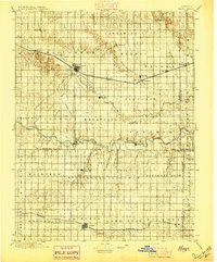
(131)- 1889 Map of Larned, 1957 Print
 1889 Larned1957 Print · USGSWestern Kansas at the close of the frontier era shows a landscape being rapidly transformed by the iron rail and river commerce. Genealogists and historians can trace early township growth and rail stations like Rush Centre, Roselle, and the hub at Larned.
 - 1891 Map of Larned
 1891 Larned1891 Print · USGSLarned and the surrounding Kansas plains were undergoing a rapid transformation into a rail-and-river economy in the late 1880s. Local researchers can trace the growth of Larned at the river forks or follow the path of the Atchison Topeka and Santa Fe Railroad through towns like Rush Centre and Garfield.5 unique versions available
 - 1892 Map of Ness
 1892 Ness1892 Print · USGSWestern Kansas at the turn of the century reveals a landscape shaped by the Atchison Topeka and Santa Fe Railroad and prairie watercourses. Researchers can locate early post offices and rail stops like Schoharie P.O., Bazine, and Jetmore.
 - 1893 Map of Ellis
 1893 Ellis1893 Print · USGSRailroad expansion and high plains river topography define this corner of Western Kansas in the early 1890s. Researchers can trace the early townships and find specific landmarks like Round Mound, the town of Ellis, and the corridor of the Union Pacific Railroad.4 unique versions available
 - 1894 Map of Ness
 1894 Ness1894 Print · USGSWestern Kansas at the close of the nineteenth century was a land of new rail towns and high plains homesteads. Genealogists and historians can trace the early development of Ness City and Jetmore, alongside smaller stops like Schoharie P.O. and Bazine.5 unique versions available
 - 1896 Map of Hays
 1896 Hays1896 Print · USGSThe High Plains of central Kansas thrive in the 1890s as twin railroad corridors fuel the growth of new townships and farming communities. Genealogists can trace family roots through early settlements like Catharine, Munjor, and Liebenthal or locate family homesteads along the Union Pacific R. R. and Smoky Hill River.5 unique versions available
 - 1955 Map of Great Bend, 1966 Print
 1955 Great Bend1966 Print · USGSCentral Kansas during the mid-sixties transition reveals a landscape defined by new reservoirs and enduring rail corridors. Researchers can trace the development of towns like Hays and Great Bend or locate natural landmarks such as Round Mound and the wetlands of the Quivira National Wildlife Refuge.3 unique versions available
 - 1957 Map of Great Bend
 1957 Great Bend1957 Print · USGSCentral Kansas at the peak of the postwar era shows a landscape of growing rail hubs and massive new water projects. Trace the routes of the Union Pacific through Hays or locate the newly formed shorelines of Cedar Bluff Reservoir and Kanopolis Reservoir.
 - 1958 Map of Great Bend
 1958 Great Bend1958 Print · USGSCentral Kansas in the late fifties reveals a landscape of high-plains agriculture and vital river crossings. Researchers can trace the development of regional hubs like Hays and Russell, or locate historic sites such as Fort Larned and the Cheyenne Bottoms wildlife area.2 unique versions available
 - 1965 Map of Otis, 1967 Print
 1965 Otis1967 Print · USGSThe town of Otis is captured in the mid-sixties as a center of Kansas energy production and agriculture. Researchers can trace the rail-side refinery, the Bureau of Mines Helium Plant, and local burial sites like the Lutheran Cem.
 - 1965 Map of Mc Cracken, 1967 Print
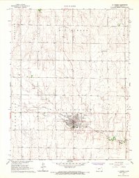
 1965 Mc Cracken1967 Print · USGSRush and Ness counties come into focus during the mid-sixties, centered on the railroad town of McCracken. Researchers can trace the Missouri Pacific line past local landmarks like McCracken Cem, Big Timber Creek, and early oil wells.
 - 1965 Map of Albert, 1967 Print
 1965 Albert1967 Print · USGSMid-century Barton and Rush counties are captured here as a productive landscape of grain and gas along the Walnut Creek valley. Trace the early energy boom through the local GAS FIELD or locate family sites at Shaffer, Walnut View Sch, and the Albert Cem.
 - 1966 Map of Alexander, 1967 Print
 1966 Alexander1967 Print · USGSThe rural landscapes of Rush and Ness counties are captured here in the mid-1960s, centered on the rail-side town of Alexander. Genealogists and historians can trace the Atchison Topeka and Santa Fe line, old quarries, and the Weber Oil Field.
 - 1966 Map of Rush Center, 1967 Print
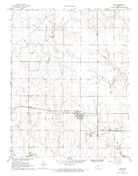
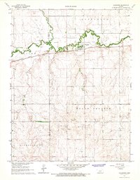
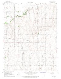
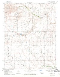
 1966 Rush Center1967 Print · USGSRush Center and the surrounding townships are documented in the mid-1960s as a vital hub for rail and oil. Researchers can trace the Atchison Topeka and Santa Fe line, locate Locust Hill Cem, and see the extent of the Rush Center Oil Field.
 - 1966 Map of Nekoma, 1967 Print
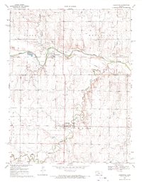
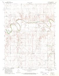
 1966 Nekoma1967 Print · USGSRush County agriculture meets the railroad in the 1960s as the rail line follows the winding course of Walnut Creek. Researchers can locate several burial grounds like Abbey Cem and early energy sites including various Oil Wells near Nekoma.
 - 1966 Map of La Crosse, 1967 Print
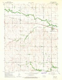
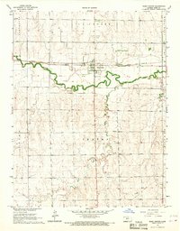
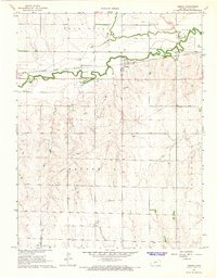
 1966 La Crosse1967 Print · USGSLa Crosse was a busy rail-centered town in the mid-1960s, serving as a hub for the surrounding Rush County farm country. Local historians can trace family sites at St Michaels Cem or locate community landmarks like the County Fairground and Grass Park.2 unique versions available
 - 1966 Map of Hargrave, 1967 Print
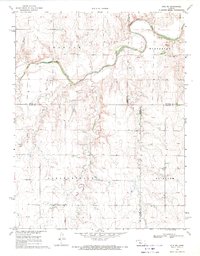
 1966 Hargrave1967 Print · USGSRush County farming and rail life are preserved here during the mid-sixties, centered on the Missouri Pacific tracks. Genealogists can locate family sites near Hampton Cem and Hall Cem, or trace the winding course of Big Timber Creek.
 - 1966 Map of Bison, 1967 Print
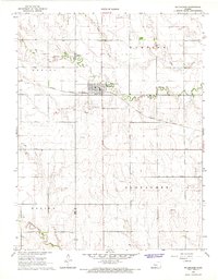
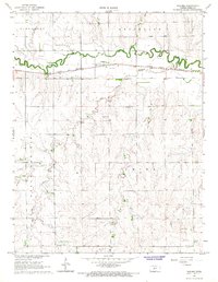
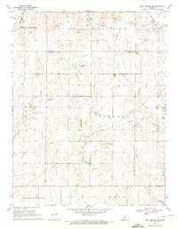
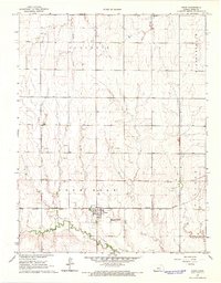 1966 Bison1967 Print · USGSBison and the surrounding Rush County plains are captured here in the mid-1960s, a period when rail and agriculture still defined the local rhythm. Genealogists can locate family sites near Lone Star Cem, the Baptist Cem, or along the Missouri Pacific tracks.
 - 1966 Map of Timken, 1967 Print
 1966 Timken1967 Print · USGSRush County agriculture and industry meet in the mid-1960s as the rail line and river valleys define the local landscape. Genealogists can locate Holy Cross Cem and Bohemian Cem while tracing the Atchison Topeka and Santa Fe railroad through Timken.
 - 1968 Map of Liebenthal, 1971 Print
 1968 Liebenthal1971 Print · USGSThe Rush and Ellis County border comes alive in the late sixties as the river-and-rail landscape shifts between agriculture and industry. Genealogists and local historians can locate Liebenthal and Schoenchen, tracing family roots at St Joseph Cem and St Anthony Cem.
 - 1968 Map of La Crosse NW, 1971 Print
 1968 La Crosse NW1971 Print · USGSIn the late 1960s, the plains of western Kansas were a landscape of cattle, oil, and river-valley farming. Genealogists and researchers can locate family burial sites at Cordia Cem and Nickel Cem or trace the early energy economy through several Oil Wells.
 - 1969 Map of Pfeifer, 1971 Print
 1969 Pfeifer1971 Print · USGSThe Smoky Hill River valley and the rural townships of Ellis and Rush Counties are captured here in the late sixties. Genealogists and local historians can trace family sites near Pfeifer, Loretta, Holy Cross Cem, and the many Oil Wells dotting the plains.
 - 1969 Map of Otis NE, 1971 Print
 1969 Otis NE1971 Print · USGSFour rural townships in central Kansas come into focus during the late 1960s as oil extraction begins to mark the agricultural landscape. Genealogists and historians can locate family landmarks like Pleasantdale Cem or trace the winding course of the Smoky Hill River and Duck Creek.
 - 1970 Map of Rush Center SW, 1972 Print
 1970 Rush Center SW1972 Print · USGSThe Rush and Pawnee County borderlands are shown here in the early 1970s, at a time when petroleum production was reshaping the prairie. Researchers can trace the development of the Shiley Oil Field and Oro Oil Field or locate the local Townhall.
 - 1970 Map of Bazine SE, 1972 Print
 1970 Bazine SE1972 Print · USGSPawnee and Ness Counties are captured here during a peak era of petroleum production in the early seventies. Genealogists and local historians can trace the specific locations of the Schadel Oil Field, Steffen Oil Field, and landmarks like High Point.
Showing maps 1-25 of 131
Top cities of Rush County
- La Crosse historical maps
- Otis historical maps
- Bison historical maps
- McCracken historical maps
- Rush Center historical maps
- Liebenthal historical maps
See more
Frequently asked questions
- What are the different types of historical maps available for Rush County?
- What is the oldest map of Rush County?
- Where can I purchase historical maps of Rush County for my home or office?
- Where can I download high-res historical maps of Rush County?
- Are there historical topographic maps available for Rush County?
- Is there historical aerial imagery available for Rush County?
- Where are historical maps of Rush County sourced from?