1970s Maps of Rush County, Kansas
Explore 5 historic maps of Rush County from the 1970s. These maps offer a rare glimpse into what life looked like during the 1970s — showing old roads, neighborhoods, homes, and landmarks that have changed or disappeared over time.
Whether you're researching your family's past, planning a metal detecting trip, or studying how Rush County's landscape evolved across the 1970s, these high-resolution maps are a powerful tool for exploring the history of this region.
- Focus on a specific era: All maps on this page are from the 1970s, giving you a focused view of this time period.
- See what’s changed: Compare century-old streets, trails, and buildings to today's modern landscape using overlays and satellite layers.
- Research with precision: Use these maps for genealogy, historical research, land use analysis, or educational projects.
- View, download, or print: Maps are fully viewable online in high resolution, and can be downloaded or printed for your own records.
Start exploring Rush County's history through authentic maps from the 1970s. This is your window into the past.
Rush County, KS maps
(5)- 1970 Map of Rush Center SW, 1972 Print
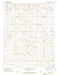 1970 Rush Center SW1972 Print · USGSThe Rush and Pawnee County borderlands are shown here in the early 1970s, at a time when petroleum production was reshaping the prairie. Researchers can trace the development of the Shiley Oil Field and Oro Oil Field or locate the local Townhall.
 - 1970 Map of Bazine SE, 1972 Print
 1970 Bazine SE1972 Print · USGSPawnee and Ness Counties are captured here during a peak era of petroleum production in the early seventies. Genealogists and local historians can trace the specific locations of the Schadel Oil Field, Steffen Oil Field, and landmarks like High Point.
 - 1970 Map of Albert SE, 1972 Print
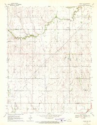 1970 Albert SE1972 Print · USGSPawnee County agricultural and oil lands are captured here in the early seventies as the energy industry expanded across the Kansas plains. Researchers can locate the Rutherford Oil Field, a rural Cem, and the winding path of Walnut Creek.
 - 1970 Map of Ash Valley, 1972 Print
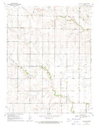 1970 Ash Valley1972 Print · USGSPawnee and Rush Counties are captured in the early 1970s, showcasing a rural Kansas landscape defined by shifting infrastructure and quiet settlements. Researchers can locate the Ash Valley Cem and trace the path of an Old Railroad Grade and regional Pipeline routes.
 - 1970 Map of Rush Center SE, 1972 Print
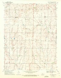 1970 Rush Center SE1972 Print · USGSPawnee and Rush Counties are captured in the early seventies, showing a rural landscape defined by ranching and energy extraction. Researchers can trace the Old Railroad Grade past Vaughn or locate historical Oil Wells and a Sandpit along the creek beds.
End of results
Showing maps 1-5 of 5
Top cities of Rush County
- La Crosse historical maps
- Otis historical maps
- Bison historical maps
- McCracken historical maps
- Rush Center historical maps
- Liebenthal historical maps
See more
Frequently asked questions
- What are the different types of historical maps available for Rush County?
- What is the oldest map of Rush County?
- Where can I purchase historical maps of Rush County for my home or office?
- Where can I download high-res historical maps of Rush County?
- Are there historical topographic maps available for Rush County?
- Is there historical aerial imagery available for Rush County?
- Where are historical maps of Rush County sourced from?