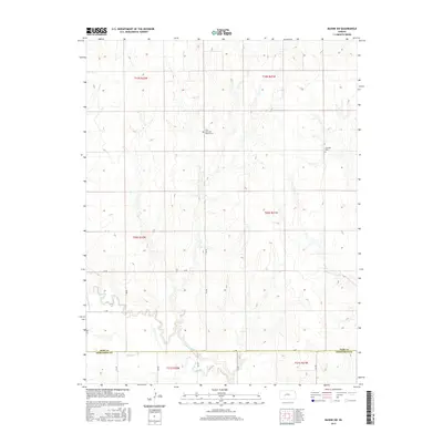
2015 Map of Bazine SW
USGS Topo · Published 2015About this map
The Ness Co Hodgeman Co boundary line divides this prairie landscape, where the meandering course of the Pawnee River and its tributary Sand Cr define the local drainage. Life in this rural section of Ness County revolves around a traditional grid of section lines, including Aa RD, 10 RD, and 20 RD, which connect scattered homesteads and agricultural operations. Evidence of early settlement and community history is preserved at two distinct burial grounds: Saint John the Baptist Cem and Crandall Cem, which serve as permanent landmarks in an otherwise open terrain. The mapping reflects a late-period survey of the high plains, showing how the original Public Land Survey System township and range divisions—such as t20s r21w—continue to dictate the modern road network and land ownership patterns.
Find a feature on this map
22 named features on this map. Tap any name to fly to it.
Don’t see what you’re looking for? This feature index may not catch every label — zoom into the map to look around manually.
Map Details
Editions of this 2015 Bazine SW Map
This is the sole edition of this map. No revisions or reprints were ever made.
Other maps of this area

1892 · Ness
USGS Topo · 1:125,000

1894 · Ness
USGS Topo · 1:125,000

1955 · Great Bend
USGS Topo · 1:250,000

1957 · Great Bend
USGS Topo · 1:250,000

1958 · Great Bend
USGS Topo · 1:250,000

1966 · Alexander
USGS Topo · 1:24,000

1966 · Ness City NE
USGS Topo · 1:24,000
1966 · Bazine
USGS Topo · 1:24,000

1970 · Hanston NW
USGS Topo · 1:24,000

1970 · Jetmore NE
USGS Topo · 1:24,000