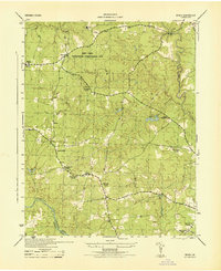
1944 Map of Beach
USGS Topo · Published 1944About this map
The Swift Creek Recreational Demonstration Area dominates the northern half of this landscape, a significant public works and conservation project that includes the presence of a CCC Camp and Camp Baker. This mid-century survey reflects the transitional character of Chesterfield County, where established farming communities and rural institutions sit alongside developing recreational lands. A dense network of local landmarks provides a clear look at 1940s community life, with several churches and schools such as Mt Gilead Church, Lees Chapel, and Union Branch School serving as the social anchors for residents near the village of Beach. To the south, the terrain slopes toward the Appomattox River, which forms the border with Dinwiddie County. The landscape is carved by numerous watercourses, including First Branch, Second Branch, and Third Branch, which feed into the larger creek systems and support landmarks like Crostick Pond and Lake Margaret.
Find a feature on this map
33 named features on this map. Tap any name to fly to it.
Don’t see what you’re looking for? This feature index may not catch every label — zoom into the map to look around manually.
Map Details
Editions of this 1944 Beach Map
This is the sole edition of this map. No revisions or reprints were ever made.
Other maps of this area

1894 · Bermuda Hundred
USGS Topo · 1:62,500

1894 · Petersburg
USGS Topo · 1:62,500

1897 · Amelia
USGS Topo · 1:125,000

1938 · Drewrys Bluff
USGS Topo · 1:24,000

1943 · Chesterfield
USGS Topo · 1:31,680

1943 · Hallsboro
USGS Topo · 1:31,680

1943 · Beach
USGS Topo · 1:24,000

1943 · Church Road
USGS Topo · 1:24,000

1943 · Winterpock
USGS Topo · 1:24,000

1943 · Sutherland
USGS Topo · 1:24,000