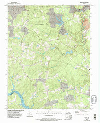
1994 Map of Beach
USGS Topo · Published 1996About this map
Chesterfield and the settlement of Beach anchor this mid-1990s survey of southern Virginia, where the landscape transitions from the dense timber of Pocahontas State Forest to the reservoir waters of the south. The sprawling acreage of Pocahontas State Park dominates the northern section, while the southern boundary is defined by the course of the Appomattox River and the significant expanse of Lake Chesdin. Local history is preserved in several small burial grounds, including Witson Cem, Dahl Cem, and Traylor Cem, which are scattered among the drainages of Second Branch and Rita Branch. The map records a rural network of water-managed features like Cimslick Millpond and Gills Pond, illustrating how local hydrology has been harnessed for recreation and utility in the decades following the mid-century.
Find a feature on this map
26 named features on this map. Tap any name to fly to it.
Don’t see what you’re looking for? This feature index may not catch every label — zoom into the map to look around manually.
Map Details
Editions of this 1994 Beach Map
This is the sole edition of this map. No revisions or reprints were ever made.
Other maps of this area

1894 · Bermuda Hundred
USGS Topo · 1:62,500

1894 · Petersburg
USGS Topo · 1:62,500

1897 · Amelia
USGS Topo · 1:125,000

1938 · Drewrys Bluff
USGS Topo · 1:24,000

1943 · Chesterfield
USGS Topo · 1:31,680

1943 · Hallsboro
USGS Topo · 1:31,680

1943 · Beach
USGS Topo · 1:24,000

1943 · Church Road
USGS Topo · 1:24,000

1943 · Winterpock
USGS Topo · 1:24,000

1943 · Sutherland
USGS Topo · 1:24,000