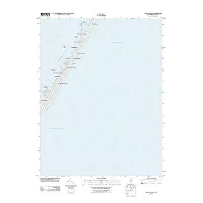
2011 Map of Beach Haven
USGS Topo · Published 2011About this map
The barrier island landscape of Long Beach Island is meticulously documented, showing a continuous string of coastal settlements from Brant Beach south to Beach Haven. This narrow strip of land is defined by the contrast between the vast Atlantic Ocean and the sheltered waters of Little Egg Harbor. The map reveals a densely developed grid of streets such as Long Beach Blvd and Ocean Blvd, connecting distinct neighborhoods like Peahala Park, Beach Haven Crest, and Spray Beach.
Find a feature on this map
40 named features on this map. Tap any name to fly to it.
Don’t see what you’re looking for? This feature index may not catch every label — zoom into the map to look around manually.
Map Details
Editions of this 2011 Beach Haven Map
This is the sole edition of this map. No revisions or reprints were ever made.
Other maps of this area

1887 · Atlantic City
USGS Topo · 1:62,500

1888 · Little Egg Harbor
USGS Topo · 1:62,500

1888 · Long Beach
USGS Topo · 1:62,500

1893 · Little Egg Harbor
USGS Topo · 1:62,500

1893 · Long Beach
USGS Topo · 1:62,500

1894 · Atlantic City
USGS Topo · 1:62,500

1919 · Long Beach
USGS Topo · 1:62,500

1920 · Little Egg Harbor
USGS Topo · 1:62,500

1940 · Atlantic City
USGS Topo · 1:62,500
1941 · Atlantic City
USGS Topo · 1:62,500