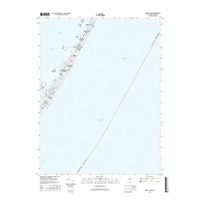
2016 Map of Beach Haven
USGS Topo · Published 2016About this map
Long Beach Island dominates this coastal survey, appearing as a slender thread of developed land separating the Atlantic Ocean from the waters of Little Egg Harbor. The map documents a dense progression of shore communities stretching from Brant Beach south through Beach Haven Crest, Brighton Beach, North Beach Haven, and Beach Haven Gardens. This layout illustrates the intense mid-century and later residential development typical of the Jersey Shore, where a single thoroughfare, Long Beach Blvd, serves as the primary spine for dozens of tightly packed street grids. To the west, the Intracoastal Waterway winds through a complex of small islands, including Ham Island and the Marshelder Islands, which provide a natural buffer for Harris Harbor. The southern reach terminates at Beach Haven Inlet, marking the dynamic point where the island's southern tip meets the open sea.
Find a feature on this map
57 named features on this map. Tap any name to fly to it.
Don’t see what you’re looking for? This feature index may not catch every label — zoom into the map to look around manually.
Map Details
Editions of this 2016 Beach Haven Map
This is the sole edition of this map. No revisions or reprints were ever made.
Other maps of this area

1887 · Atlantic City
USGS Topo · 1:62,500

1888 · Little Egg Harbor
USGS Topo · 1:62,500

1888 · Long Beach
USGS Topo · 1:62,500

1893 · Little Egg Harbor
USGS Topo · 1:62,500

1893 · Long Beach
USGS Topo · 1:62,500

1894 · Atlantic City
USGS Topo · 1:62,500

1919 · Long Beach
USGS Topo · 1:62,500

1920 · Little Egg Harbor
USGS Topo · 1:62,500

1940 · Atlantic City
USGS Topo · 1:62,500
1941 · Atlantic City
USGS Topo · 1:62,500